6. 1860’s development of the Solitary community in Wattle Flat
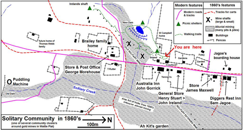
Several historic maps have been discovered in archives which graphically show the 1860’s development of the local community. These have been compiled to create the map below.

A surprising aspect revealed by this map is the large extent of ground that was intensively mined for alluvial gold. This gold was shedding from numerous quartz reefs, the most dominant of which was the Solitary Reef which is represented by a line of mine shafts (* & x’s). A puddling machine (one of a great many in Wattle Flat), operated below an earth dam in Solitary Creek a few hundred metres upstream to the south of the Solitary Reef .
The modern main road follows a major access track developed in the 1860’s with some straightening of the bends to the south of the Solitary Reef. One 1860’s track heads east from the Old Solitary Mine and would have been the shortest route to cart the quartz to the only stamp battery then established 2 km away at the head of Big Oakey Creek. This track passes Ah Kit’s Chinese gardens, which lie close to the tennis courts at the Brae Lane Recreational Grounds.
During the mid to late 1850’s there would have been hundreds of miners living in the Solitary area. It is not surprising that several stores & public houses (Hotels or Inns) flourished in this area. Two Hotels were the Australia Inn run by John Gorrick a retired famous boxer, and the Diggers Rest Inn run by Sam Jagao & his wife Sarah (nee McCudden). Three larger stores were held by Morehouse, Stuart (& Ireland) and Maxwell. Smaller stores may have been run by Smeed, Crawford, & Yennan. A blacksmith’s shop is said to have operated next to the Australia Inn. George Morehouse operated the Wattle Flat post office service from his store.
The likely homes of 3 of the defining characters of the Solitary Mine history (Campbell, Brailey & Webb) are identified on the map. Johnson the miner who became a well-known Sydney journalist lived at Jargoe’s boarding house during the early 1860’s.