Background
Much is written about Sofala & Bathurst during the beginning of the goldrush period, but there is not so much about Wattle Flat. This item attempts to fill the void. (Note: Words in italics are quotations from historic newspapers.)
Prior to the official discovery of gold in this district (mid 1851), firstly at Ophir, and then at several localities including Sofala on the Turon River, the only colonial interest in this hilly area was for grazing sheep. Several farms where already established in the larger broad valleys extending northwards from Bathurst including those near the settlements of “Green Swamp” (now Napoleon Reef, east of Bathurst on the Sydney road) and “Peel”. One of the most northerly developed valley farms in this area was Wyagdon, associated with two early 1000 acre holdings held by George Suttor & by Richard Lewis.
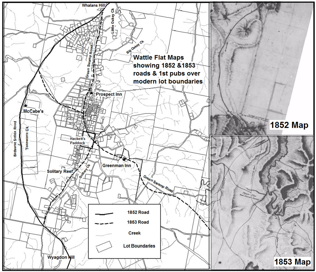
It seems that just prior to the discovery of gold, the McCabe family held most of the land on the Wattle Flat tableland, with a farm station at McCabe’s Flat, at the site of Tanwarra Station homestead today. This is clearly shown on a 1852 surveyors map of the Bathurst to Sofala road.
A Mr White is recorded as holding a station above the head of Big Oakey Creek in 1852, and a man named Hackett is recorded as having made a claim for 30 acres of grazing land before 1851 in the middle of what is now Wattle Flat village.
The earliest formed track through Wattle Flat
The earliest access track onto the Wattle Flat tableland that was presumably used by the McCabe family ascends from the Wyagdon farm in the valley up a steep spur onto the tableland. It then follows Tanwarra Creek from its headwaters to McCabe’s Flat.
Following the discovery of gold in The Turon, and the ensuing rush of people to seek their riches, McCabe’s farm access track became the first road to Sofala, passing 1.5kms west of the future site of the Wattle Flat village. This road continued northwards from McCabe’s farm over a shallow saddle into a tributary of Little Oakey Creek, passing on the SE side of Whalan’s hill, and then traversing along the steep western side of Little Oakey Creek into the Turon valley & the rapidly developing township of Sofala.
Realignment of the track up Wyagdon Hill to reduce its steepness
During the latter part of 1851 tens of thousands of gold seekers, other investors & colonial administrators etc. would have passed along this road. To facilitate the heavy traffic on this road, successive realignments & improvements were made, with the carving out of zig–zag passes with cuttings & embankments navigating the steeper sections on Wiagdon Hill, and Little Oakey Creek gorge.
Henry Rotton (an entrepreneurial Bathurst publican) establishes and runs a stage coach company that services the demand for improved transport between Bathurst & Sofala in 1851. Resting places for both the horses & people were established along the road at strategic places.
“A new public-house, called the Wyagdon Hotel, lies between this creek (Cheshire Creek) and the (Wyagdon) hill, where the traveller experiences almost as much comfort, and fully as much civility, as in any public-house in Sydney”.(Empire, 1852)
In this area most of the gold seekers initially head for Sofala, but as time goes by more & more start working their way up the gold bearing creeks towards Wattle Flat. This migration is particularly strong during February 1852 when severe flooding occurred in low lying areas including the Turon River diggings. This is the setting for the initial road development & settlement in Wattle Flat. The first part of Wattle Flat to be settled seems to be the area south of Whalan’s Hill, (3km north of the present village area).
The following newspaper excerpts illustrate some aspects of life in Wattle Flat during these years.
“A solitary sheep station (McCabe’s?) is the only sign of a permanent human habitation between Wyagdon and Sofala. About half a mile beyond, the first signs of gold digging present themselves. Here are three or four holes in which the water has been retained by damming up a dry creek, upon which there are as many cradles at work. The auriferous earth is conveyed hither in drays and carts from the head of Little Oakey Creek— a distance of about a mile and a-half. The men appear to be well satisfied with their earnings, which they say average from 1½ ounces to 2½ ounces per day.
In a rugged and broken country such as the Turon, these ravines are very numerous, and although many of them retain water for a short period only, the almost continuous rains of the past four months have kept up a plentiful supply, and from some of them large quantities of gold have been taken. Numbers of men, some of them in the prime of manhood, others in the vigour of youth, and not a few hoary and bent with years, were returning from Sofala, laden with the following week’s provisions, and were wending their way to their distant mountain homes.”(BFPMJ, 1851)
“The Wattle Flat, a tableland stretching from the Wyagdon to the Turon ranges, is intersected in various directions by chains of ponds or waterholes. Upon these small bands of diggers, numbering from eight to a dozen, are rocking their cradles until the waters of the Turon shall have subsided sufficiently to allow the bed claims to be worked.” (BFPMJ, 1852).
“ In Solitary Creek, a tributary of Oakey I fell in with a mulatto, recently from California, a fine, handsome specimen of the ‘genus homo’ who was working a small “tom” by himself, with which he had cleared half an ounce up to twelve o’clock that morning. He stated that he could generally make an ounce a day by himself when there was plenty of water. However, he complained of the poverty of those diggings as compared with those of California, …” (Empire, 1852).
Nearly all the attention of the miners is focused on alluvial gold at this time, but there is reference in 1852 to two mining syndicates seeking permission to start reef mining at the Solitary Reef in Wattle Flat. There is however, official concern that this might interfere with the alluvial mining in the same area.
A new track – the Green Swamp Road (Limekilns Road) established by 1853
By 1853 an alternate track from Sofala to Bathurst was opened through the Limekilns area and on to “Green Swamp” on the Sydney Road. This was then known as the Green Swamp Road. It started at a junction with the Bathurst Road just south of Whalan’s Hill, and proceeded south into the area of the modern day Wattle Flat village centre, & then headed SE across Solitary Creek close to the new bridge. From here it headed SE over a shallow rise & into the Big Oakey Creek valley at the site of the Greenman Inn, and on in a SE direction towards Limekilns.
At this time, two other link tracks are shown on an 1853 map of Wattle Flat. One links between the Solitary Ck crossing and the head of Wiagdon hill. The other links the modern village centre and Tanwarra Ck to the west. These provided good access to the rich alluvial fields at Pipers or Chinaman’s Flat to the west, Upper Solitary Creek to the south, and Bullock Flat to the east. There would have also been a lot of continuing alluvial mining activity in the gorges draining north from the Wattle Flat tablelands including Spring Creek, and Little & Big Oakey Creeks.
As Wattle Flat starts to be recognised as the source area of much of the alluvial gold, the population starts to increase significantly. Essential to a vibrant community like this are public houses, with licences to sell liquor. It seems that the earliest properly established pub in Wattle Flat was the Prospectors Inn (established 1852) located just north of the church on the north side of the village. The next issue (Item 3) will cover the development of the earliest pubs & businesses in Wattle Flat.
(Researched & written by Chris Green, July 2017)